|
The Soviet Franz Josef Land Overflight by Page 2 of 2 Pages |
||||||||||
 |
 |
|||||||||
|
Airborne to Franz Josef Land
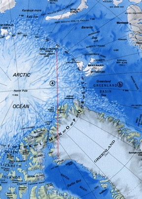
Continued Goolsbee set the power for our climb-out, while Heiman, our Radar Navigator, monitored our climb over Baffin bay. At about 6,000 feet, as we continued to climb I made a right turn to our planned Grid heading, where we leveled off on top of a lower cloud deck at 18,000 feet. After level off our normal procedure was to start using fuel from the 700 gallon pylon fuel tanks, which were mounted beneath each outboard wing panel. Soon after we started using fuel from the wing thanks, Goolsbee advised me that he had a problem. The fuel tank booster pump circuit breaker for the right pylon tank had popped out and after trying to reset it several times, he could not get it to stay set. It was apparent that we had a booster pump failure. We judged that we had 600 to 700 gallons of fuel ramaining in the tank that would not be available. We knew that we would have sufficient fuel to complete the mission, however having enough fuel to reach our alternate in the event that we could not land at Thule was questionable. I made the decision that we would proceed as planned. Navigation in the “high arctic”, requires a totally different approach as well as a high degree of professional ability and experience as well as attention to detail. Normal long range navigation procedures, as conducted in the lower latitudes, cannot be employed in the arctic above 70 degrees north latitude. The establishment of a direction to maintain a true course is one of the most difficult problems. It is not possible to employ a magnetic compass for direction because of errors imposed by the location and orientation of the magnetic pole. A directional gyro compass heading degrades near the pole. A fluxgate compass is best but at the poles it looses some directive effect and requires constant resetting, according to the navigators plot of direction as the flight progresses. To assist in solving the problem of true direction, A SAC devised navigation system known as “Grid” navigation is employed. It requires plotting a true course as a grid course. The establishment of a grid direction is derived from the angular relationship in degrees from the true course and a meridian of longitude at the starting point. The grid direction remains constant for its length. (ending point) |
||||||||||
| Jack Welch, our primary navigator; Donald Burkhead, who was assigned to augment our crew for this mission; and our radar navigator, Grover Heiman, planned and implemented the navigational part of the mission. The RB-50 had a communication tunnel running over the top of the bomb bays that provided the crew with a means of access between the forward part of the aircraft and the rear, similar to that on a B-29. In the forward end of the tunnel was a plastic dome, which is called an astro dome. An astro compass was mounted in this position. Welch sat in the forward end of the tunnel under the dome, using the astro compass, taking almost constant readings on the azimuth of the sun. Burkhead, who had the most difficult job, worked at the navigators desk. He was responsible for maintaining a dead reckoning plot of position, applying and averaging the astro compass readings given to him by Welch, so as to plot a line of position, compute wind direction, wind velocity and ground speed. | ||||||||||
 |
||||||||||
|
Additional, more detailed, maps are found in attachment #3. If you wish to view these maps, click here with an easy return with your back button. |
||||||||||
| The progression of the flight required nearly constant corrections to the fluxgate compass. The grid course was always the same. True course changed with the passage of each meridian of longitude.
Maintaining our altitude of 18,000 feet, with the grid course established, Welch and Burkhead were well into their routine. Heiman assisted by providing radar fixes of position while over and leaving the east coast of Greenland. In 1952 the reliability of the charts we were using was questionable because of inaccurate or incomplete surveys, possibly resulting in errors of several miles. End Page 2 of Chapter 4 — Go to Chapter 5 You may go to Cover Page — Editor's Introduction & Prologue — Table of Contents Chapters — 1 — 2 — 3 — 4 — 5 — 6 — 7 Or, you may Home - Contact Us - Cold War Hist. - 91st SRS Hist. - Stardust 40 Mission Story |
||||||||||