The Story of
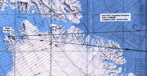
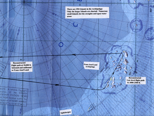
The Soviet Franz Josef
Land Overflight

by
Roy E. Kaden

Atch. #3B - Map Reference

Navigation Routes from
Thule Air Base to Franz Josef
LandArchipelago and Return

Ctsy. Standard Air Navigation Maps

Page 2 of 4 Pages

Chart Notations, Above: — Thule Air Base — Chart GNC 1, long Range Navigation Scale, 1: 5,000,000, Compiled 3/1958, Revised 1/1984
Chart Notations, Above: — Reconstructed Flight path at 18,000 ft. Inbound and Outbound to Franz Josef Land — There are 190+ Islands in the Archipelago. Ony the larger Islands dot the straights and open water areas. — Franz Josef Land Archipelago — Spitsbergen
Attachment #3B, Page 2 of 4 — Go to Page 3


You may go to

Cover PageEditor's Introduction & PrologueTable of Contents

Chapters — 1234567

Attachments — #1#2#3

Or, you may

Home - Contact Us - Cold War Hist. - 91st SRS Hist. - Stardust 40 Mission Story
RB-29 Crew Hist. - Hiking Rural Japan - Extended Stories - Short Stories
Biographical Notes - Current Commentary - Art Gallery - Fun Stuff - Education
Programs
- Locator- Reunions - Memorials - Cold War Museum Web Site